
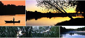
Alligator Hunting: A One of a Kind Experience -
Why They Call it Hunting Instead of Killing -
Florida's Other Crab - by Kris Thoemke
The Waiting Game - by Kris Thoemke
Mounted Memories - by Kris Thoemke
Eco-Touring in Collier County - by Kris Thoemke
Beyond the Largemouth Bass - by Kris Thoemke
Tying One On -- Some thoughts on how to get started tying your own flies -- by Kris Thoemke
The Big Cypress: Adventures in a Vast Wilderness
Four Strokes on the Water -- The sound of the future for marine outboards is likely to be much quieter --
Birding Big Cypress Swamp and the 10,000 Islands --
Recycling Your Fish -- by Kris Thoemke
Peace, Paddle and Hunt -- by Kris Thoemke
by Kris Thoemke
by Kris Thoemke
-- Kris Thoemke spends the day exploring the Big Cypress National Preserve with Preserve biologist Debra Jansen
by Kris Thoemke
by natural history writer and photographer Jeff Ripple
A Basic Guide to Saltwater Fly Fishing in Southwest Florida
C 1996, Don Phillips
Chapter 8 - Fishing the Tides
Tidal action is the engine that drives the entire biosphere of the backcountry. Passes and creeks
bring in fresh saltwater from the Gulf of Mexico and about 6 hours later discharge a more dilute
mixture back into the Gulf. Flats and mangroves are alternately flooded and exposed to provide
the nutrients needed by baitfish and crustaceans. This repetitive flooding and flushing creates
natural channels through which all forms of life travel. These channels can be from a few up to a
few hundred yards wide and they can be a few inches or several feet deeper than the surrounding
bottom contour. Photoplankton drift helplessly with the current and the baitfish follow, for this
is their main food source. Gamefish travel these routes and use instinctive chase and ambush
strategies to satisfy their hunger. The fly fisherman also uses these "highways" to gain access to
his prey, the gamefish. By gaining familiarity with the tides and the location of the channels, the
fly fisherman can locate the places where gamefish are feeding and the times that their feeding is
apt to be most aggressive. More about "places" in the next chapter.
Knowledge of the timing and strength of the tides is essential to making a fishing outing both
productive and safe. If you're just starting to fly fish in a new area, you should extend your range
gradually, as you gain familiarity with what's both above and below the waterline. I have a series
of sketches which I've drawn of most of the local bays, showing the deepest routes, sandbars,
oyster bars etc. The most important step however is to correlate your local knowledge with
published tide tables so that you'll have an idea of whether or not you can travel a particular
route at a given time. I disagree strongly with some people who belittle the importance of tide
tables. They say that other environmental factors such as wind and barometric pressure make the
charts innacurate. My response to these detractors is that I would much rather start out with a
quantitative picture of the tides and then adjust this data based on other considerations, rather
than just wing it and play it by the seat of my pants.
There are many different sources of tide data, but I find Florida Sportsman's annual Tide Atlas to
be the best because of the informative way in which the data is presented. Please refer to the
enclosed pictorial for the following comments. This is a partial page from the "St. Marks"
section of the 1993 Tide Atlas. I do most of my fishing around Marco Island and, per the
instructions in the Atlas, I subtract 1 hour and 4 minutes from the high tide data, 1 hour and 8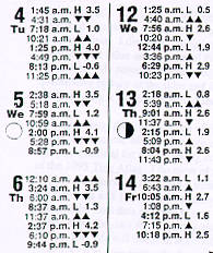 minutes from the low tide data and 1 hour and 6 minutes from the mid-tide data (where the dark
triangles are), to estimate the tidal data at Little Marco Pass, the main northerly source for flow in
the Marco River. Note the data for Thursday, the 6th of May. The chart tells us that in Little
Marco Pass the first low tide will occur at 8:37-1:08=7:29 a.m. and that the first high tide will be
at 2:37-1:04=1:33 p.m. Similarly, the 2nd low tide will occur at 9:44-1:08=8:36 p.m.
minutes from the low tide data and 1 hour and 6 minutes from the mid-tide data (where the dark
triangles are), to estimate the tidal data at Little Marco Pass, the main northerly source for flow in
the Marco River. Note the data for Thursday, the 6th of May. The chart tells us that in Little
Marco Pass the first low tide will occur at 8:37-1:08=7:29 a.m. and that the first high tide will be
at 2:37-1:04=1:33 p.m. Similarly, the 2nd low tide will occur at 9:44-1:08=8:36 p.m.
Also note that there are adjacent numbers which estimate the water surface levels at that tide on a
gauge at the St. Marks River entrance. Although these water levels don't directly apply to the
Marco area, we can correlate them to our local water levels. For example, suppose that you often
fish a flat whose actual low-tide depth is about 1 foot, when the St. Marks gauge reads 1.3 feet.
With most backwater boats 1 foot of water is sufficient for either poling, using a trolling motor
or running up on plane. And so, the first low tide of that day should be OK for crossing or
fishing, if the wind or barometric pressure are not important factors. Notice the 2nd low tide,
however; it is -0.9 feet or over 2 feet lower! If you're fishing further into the mangroves late
that day, you might want to start for home well before low tide or have another route back to
deeper water. This is certainly not the time of day to get stuck on a sandbar! As you familiarize
yourself with your area and the tide tables you will get to know these benchmarks and use the
gauge levels to guide your fishing plans.
Another use for the gauge levels is to determine the difference between high and low tides to
obtain a measure of the strength of the tide. Again, using Wednesday, May 6, the difference
between the first low tide and the first high tide is 4.2-1.3=2.9 feet. Similarly the difference
between the first high tide and the 2nd low tide is 4.2-(-0.9)=5.1 feet. Now look at the difference
between the first high tide and the second low tide for Thursday, April 13. Here there's only 0.7
feet difference, a very weak tide. These three tides can be classified as moderate, strong and
weak respectively, and you'll notice the double, triple and single triangles denoting these relative
strengths. These triangles are referenced to the mid-tide time, which is the time when tidal flow
is at its greatest. They are great for checking future fishing dates if you want to concentrate on
those days and tides where the flow is the greatest. What are some of the other things which you
might infer from these data? Well, first of all, the water is really going to be pouring out of the
bays late afternoon on May 5 and if you can find some good gamefish cover adjacent to heavy
flow, you might enjoy some fine fishing. Another thing you might infer is that you may not be
able to fish in an upstream direction while in some channels, depending on the power of your
trolling motor. For May 13, you can figure that there isn't going to be much water moving for
most of the day and so you might want to concentrate on places like flats and bays where tarpon
might be laid up or where redfish cruise looking opportunistically for choice morsels.
Although knowing the tide tables is important, one must not blindly apply them across the board.
Let me mention some circumstances where additional judgement must apply. First and foremost,
although you might have a good picture of the tide situation at Little Marco Pass, keep in mind
that the situation far up into the backwater might be very different. Some remote bays may lag
the tidal inflow by up to an hour just because it takes that long for the current to get there.
Connecting bays with a restrictive channel in between can create a situation where the water level
rises rapidly in the lower bay because its outlet flow is restricted. In this instance, the upper bay
is starved for water until enough water passes through the channel (at the same time lowering the
water level in the lower bay). These circumstances are made even more complicated in those
instances where areas are influenced by more than one major pass to the Gulf. Here again, the
proper strategy is to get to know your area and its subtleties. Once you're familiar with the flow
network you can effectively apply the tide tables to your advantage.
Atmospheric conditions can also have a significant effect on tides. Wind is the number one
player in this arena. A strong onshore breeze during a falling tide can actually keep the water up
in the bays and mangroves at low tide, and then really flood the backwaters at high tide. The
reverse of course can take place with a strong offshore wind. A quartering or along-shore wind
can be similarly confounding with regard to bays and creeks affected by more than one flow from
the Gulf. Accordingly, you should always consider the effect of the wind on your fishing tides.
So, how does one use tide information to plan a fishing day? This has got to be a very personal
choice, dependent on how much of a planner you want to be. I started out just going out fishing
and moving from area to area depending on my mood and limited knowledge. This is probably
OK provided you consider the tides at your next area (before getting there) and provided you
always have a safe route to get home. I've often found that this strategy ends up with my
bouncing around all over the place, using a lot of gas and not necessarily being in the right places
at the right times. I believe a better strategy is so make a game plan beforehand, based on
anticipated tides and wind .
The plan might proceed something like this. First, pick the day that you're going to fish; either
because of favorable tides or some other factors (like that's the only day your wife would let you
go). Next, study the tide predictions and local backwater maps and pick a general area that is
likely to produce good fishing. Then, identify the specific locations you'd like to fish and work
out a route that will give you the best tides at these areas with the least amount of wasted travel
time. For example, if your day is like May 5 (per the above chart), you might first cruise the
edges of some large flats or bays close to the gulf, while they're still fairly shallow and before the
wind comes up, and look for telltale wakes or riseforms. Then as the tidal inflow reaches
maximum you might work your way along with the tide, fishing areas with good current and
progressing up into the backcountry until high tide has caught up with you. You could then
shift to a bay that is often dry at low tide (but now has a foot or so of water over it), anchor and
have lunch while keeping your eyes open for signs of fish. After lunch you might then start
working your way back toward the Gulf, probably along a different route than the one you
followed earlier in the morning, taking advantage of the strong tidal outflow. By 4:00 p.m. your
arms are probably tired from casting and catching/releasing all those fish and so it's time to get
off the water!
Having made and executed this highly successful plan, I must throw in a major caution. For the
last 10 years of my working career I was a professional planner and I learned long ago that
planning is worthwhile only if you are ready to change it in an instant if unforseen opportunities
present themselves. In other words, don't blindly follow a plan. Keep your eyes and ears tuned
for alternate opportunities, whether they are tarpon porpoising in strange places or photo shots of
our plentiful wildlife.
Next Chapter - Places for Fly-Fishing
Table of Contents