
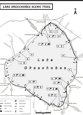
Designated as part of the Florida National Scenic Trail in 1993, the Lake Okeechobee Scenic Trail (LOST) is an approximately 110 mile trail encircling Lake Okeechobee. Most of the trail consists of crushed gravel roadway on top of the 35 feet high Herbert Hoover Dike. A 26 mile segment from the Kissimmee River to Port Mayaca is paved asphalt. The height above the surrounding lands and waters allows for excellent vistas. The trail can be utilized for short day hikes or 110 mile loop hikes. The LOST is open year round for a variety of uses including hiking, bicycling, birdwatching, fishing, and photography. Hunting is not permitted on any section of the trail. No fees or permits are required to use the trail although all users must comply with all State and Federal laws governing the area.
Trail Rules
- Firearms and fireworks are prohibited.
- Camping on the trail is allowed only at the designated sites or at Public Campgrounds.
- Pets must be kept on a leash.
- All trash must be carried out.
- Fires must be kept within the fire rings provided.
- Groundfires are prohibited.
Water
Potable water is available at locations noted on the map. Many of the local businessses will allow you to obtain their tap water, or they have bottled water for sale.
Campgrounds
There are 13 camping areas available on or adjacent to the LOST. The maximum distance between campsites on the LOST is ten miles. Four of the campgrounds are operated by local governments in the towns of Pahokee, Belle Glade, Okeechobee, and South Bay. They charge a fee while providing toilets and showers. The other primitive campsites are provided by the Corps of Engineers and consist of a shade shelter, picnic table, and fire ring. The Corps camping areas are free and have no water or toilet facilities. If there is not a fire ring at a campsite, then groundfires are not permitted. Special Concerns- The trail route requires the hiker to come down off the levee at several locations around the lake. The hiker is reminded to stay well off the highway and walk facing the oncoming traffic wherever possible. In addition, the hiker is reminded to respect the boundaries of privately owned lands.
- Alligators are common along the LOST. Store food away from sleeping areas. DO NOT FEED ALLIGATORS!
- Lightning storms are common during the summer months. Seek shelter or low ground during such storms.
Sanitation
Garbage can be deposited in any of the developed recreation areas along the trail. When camping in undeveloped areas along the trail, sanitation becomes each individual's responsibility. The goal is to always keep the evidence of humans substantially unnoticable -"Leave No Trace". Combustible material should be burned. Any soft food scraps such as fruit and vegetable peelings should be buried away from the campsite so they will decompose without being an eyesore. Empty cans, bottles, plastic, and aluminum should be carried out of the area to the nearest refuse container.
The proper disposal of human waste is most important. The individual cathole latrine is used by experienced hikers when no developed toilet facilities are available. Use a 5-6 inch deep hole in a screened spot away from the campsite, and at least 100 feet from the nearest water. After use, cover the hole with soil, and nature will take care of the rest. Emergencies Emergency situations will arise occasionally. It is always a good idea to locate the nearest telephone before you hike. should someone in your group become sick, seriously injured or lost, dial 911. Some public phone locations are designated on the map. Users of cell phones should be aware that there are some areas on the LOST where reception is poor. History Designated a National Scenic Trail in 1986, the Florida National Scenic Trail is more than 1,300 miles long. It begins at the Gulf Island Seashore near Pensacola, and ends in the Big Cypress National Preserve near Miami. The Florida Trail is part of our National Trail System. This trail is dedicated to foot travel and motorized travel is discouraged. The Florida Trail passes through a variety of ecosystems, and around Lake Okeechobee, the trail follows levees and water control structures built by the US Army Corps of Engineers.US Army Corps of Engineers
South Florida Operations Office
525 Ridgelawn Road
Clewiston, FL 33440-5399
(863) 983-8101