Places: Everglades | Wilderness Waterway | Chokoloskee Bay | Flamingo Area | Big Bend | Loxahatchee River | Hickey Creek
Withlacoochee River | Alafia River | Estero River | Hillsborough River | Little Manatee River | Peace River


Gulf Coast Area Canoe Routes
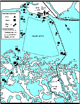
Put in at the canoe ramp next to the visitor center or the NPS ramp next to Outdoor Resorts on Chokoloskee Island. Time your trip to have the tides help you. A falling tide flows toward the Gulf of Mexico; a rising tide flows toward the visitor center. Watch your time and keep an eye on the weather. Check at the visitor center for current conditions. Be cautious of the swift currents that run through Sandfly Pass. Nautical charts are recommended; #11430 covers the Chokoloskee Bay area, and may be purchased from area stores or the Natural History Mail Order Bookshelf.
Open a map of Sandfly Island and Chokoloskee Bay (75 K) Sandfly Island Trip - 2 1/2 hours round trip (add an hour if travelling against wind and tides). Add one hour to walk the trail on the island. A marked channel leads you two miles across Chokoloskee Bay to a mangrove island. Sandfly Island has a dock and a one mile (1600 m) loop walking trail. To go onto the island it is best to land on the shore and walk to the trail, rather than attempting to get out on the dock.
Sandfly Island has a long human history. The island itself is a shell mound created by Calusa Indians. In the early 1900s European settlers had a home site, tomato farm, and even a store on the island. Nature has since reclaimed the island, and virtually no sign of human settlement remains. Before returning to the ranger station you may choose to paddle around the island; however, the oyster bar north of the island may be impassible at low tide. Watch for strong tidal currents south of the island.
Chokoloskee Bay Loop - 2 1/2 hours round trip (add an hour if travelling against wind and tides). A marked channel guides you along the margin of the Ten Thousand Islands. Mostly open water with a few small mangrove islands. Explore the small islands, but use caution, especially at high tide. The miniature world of an oyster bar can be explored at low tide, and dolphins and manatees may be seen. Wear shoes if you plan on walking in shallow water. This trip is best suited for novice canoeists.
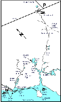
Open a map of Turner River and Halfway Creek(27 K)Turner River - 5 hours. The 8 mile (13 km) trail begins along the Tamiami Trail (U.S. 41), 1/2 mile west of the H.P. Williams Roadside Park, and ends in Chokoloskee Bay near Everglades City. The scenery changes from pine and freshwater cypress forests, to open prairie, to tropical saltwater mangrove swamp. Use extreme caution in the open prairie, as airboats frequent this area.
For a longer trip (6 to 7 hours), turn up Left Hand Turner River and go down Halfway Creek into the boating canal near the Gulf Coast Visitor Center.
Halfway Creek and Turner River Loop - 4 hours round trip (add one hour if traveling against wind and tide). Put your canoe in at the launch site behind the Ranger Station. Follow the shoreline east and paddle up Halfway Creek to Turner Lake, then return to Chokoloskee Bay or the Gulf Coast Visitor Center via Left Hand Turner River.


