
Places: Everglades | Wilderness Waterway | Chokoloskee Bay | Flamingo Area | Big Bend | Loxahatchee River | Hickey Creek
Withlacoochee River | Alafia River | Estero River | Hillsborough River | Little Manatee River | Peace River


Alafia River Canoe Trail
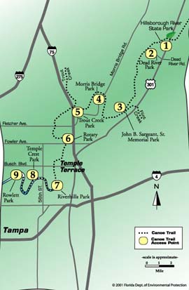
The Hillsborough River Canoe Trail is officially designated as part of Florida’s Statewide System of Greenways and Trails. The river begins in southwest Pasco County in the Green Swamp. From the Green Swamp, the River begins as an overflow from the Withlacoochee River, north of US Highway 98. Its headwaters begin as a slow moving sheet flow that percolates through a heavily vegetated riverine forest that has no discernable channel. Approximately a quarter of a mile south of its beginning point, a channel emerges and becomes more defined as a channelized riverine system. The Hillsborough River continues its 54-mile journey in a southwesterly direction through Pasco and Hillsborough Counties to Tampa Bay. The 34.5 mile designated canoe trail begins at Crystal Springs in Pasco County and terminates in Hillsborough County at the City of Tampa’s Rowlett Park.
Mileage: 34.5
Skill Level: Beginner sections are between Access Points 1 and 2 and all sections from access point 3 through 9. Intermediate sections are from Crystal Springs to the Hillsborough River State Park (upstream from Access Point 1) due to the rapids, and the “Seventeen Runs” between Access Points 2 and 3 due to the confusing nature of the riverine swamp and the number of pullovers.
Difficulty: Easy to Moderate
Usual Current: Slow (.5-1.5 mph).
Notes and Precautions
Be aware that there are rapids in the upper sections. Also, be cautious around potentially dangerous wildlife. Be prepared for encounters with motorcraft in the suburban area. Paddlers should pay close attention to the trail markers in the “Seventeen Runs” as those unfamiliar with the area could get lost.
Access
- Hillsborough River State Park – 9 miles north of Fowler Avenue on US 301.
- Dead River Park – 7.5 miles north of Fowler Avenue on US 301.
- John B. Sargeant, Sr. Memorial Park – 3.5 miles north of Fowler Avenue on US 301.
- Morris Bridge Park – 5 miles east of I-75 (Exit 55, Fletcher Avenue) on Morris Bridge Road.
- Trout Creek Park – .05 (1/2) mile east of I-75 (Exit 55, Fletcher Avenue) on Morris Bridge Road.
- Rotary Park – 0.2 miles west of I-75 on Fowler Avenue.
- Riverhills Park – 1 mile east of 56th Street on Riverhills Drive in Temple Terrace.
- Temple Crest Park - Check.
- Rowlett Park – From I-275, take Busch Blvd (Exit 33) east to N 22nd Street. Take a right (south) and look for park.
There may be access points (both public and private) in addition to those listed here. Please remember that some sites require a fee for launching and/or parking.