
Places: Everglades | Wilderness Waterway | Chokoloskee Bay | Flamingo Area | Big Bend | Loxahatchee River | Hickey Creek
Withlacoochee River | Alafia River | Estero River | Hillsborough River | Little Manatee River | Peace River
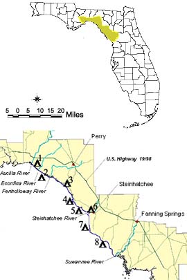
The Historic Big Bend Paddling Trail, Florida's first legislatively designated water trail, provides unique opportunities for paddlers to experience "outside" paddling with greater safety and pleasurable camping opportunities. The Big Bend is one of the least developed coast and mildest of Florida's coastal waters north of the Florida Keys and Ten Thousand Islands. Located on the Gulf of Mexico between the St. Marks River lighthouse and the Suwannee River, the area encompasses the Big Bend Aquatic Preserve, hundreds of small tidal creeks and seven medium sized rivers.
The small residential and fishing communities that dot the shoreline are accessible by road, but most are hardly visible from the coast. As you paddle along the shore you will occasionally see the roofs of houses well behind the coastal marshes and a few poles stuck in the water to indicate a channel that will take small boats "inside." Such names as the Econfina River, Spring Warrior Camp, Dekle Beach, and Keaton Beach appear on a standard road map and mark interesting small ports. St. Marks, Steinhatchee and Suwannee are the larger "cities" along the route; but all are rather quaint and quiet except on weekends when the fish are running.
Camping and Trail Use
Camping is allowed at 8 sites along the trail. Carefully check the map during your trip planning to make certain that camping spots fall within your paddling capabilities. If you are not a hardy camper, trips can be planned to take advantage of the fishing villages for overnight stays. Camping areas are usually primitive with no water or toilet facilities. Stick to the designated areas and be careful of the vegetation.
Camping areas are closed from July 1 to September 30. The Florida Fish and Wildlife Conservation Commission requires permits for camping on the property they manage. Please follow the stipulations listed on the permit in order to protect the land and keep it open for camping. Obtain these permits by contacting the Office of Recreation Services at 850-488-5520 or Click Here for the Big Bend Saltwater Paddling Trail Website.
Along the way you can find motels or small privately owned rented cabins available at moderate prices as well as small restaurants and food stores. The larger towns have marinas and bait and tackle shops as well. Secure current information from each area before starting out unless you are adventuresome. These small businesses often have hours that meet local needs and may vary depending on what fish are running at the time. They tend to open on the weekends and close during the early part of the week.
In the late spring, summer, and early fall, expect mosquitoes, no-see-ums, biting flies of various sorts as well as chiggers and ticks in the hammocks. Even during the cooler months, temporary warm spells will bring out mosquitoes and no-see-ums.
Type of Boat
The modern sea kayak serves as the ideal self propelled boat for this coast. Canoes are not well suited for the winds and waves that occasionally spring up. The sea kayak with its enclosable cockpit and low wind resistance increases efficiency by 20 to 30% and safety by 100%. If you decide to paddle this coast by canoe, plan for additional time to wait out adverse weather conditions. Because of the prevalence of oyster bars in most areas, the flexible polyethylene kayak will provide better service and a more relaxed trip. Couple this with the number of times you will have to drag your boat through mud flats at low tide, and protectors of their fiberglass boats will understand.
Maps
The Florida Fish and Wildlife Conservation Commission has a comprehensive guide to the paddling trail or you can use the NOAA 1:80,000 Nautical Charts 11405 (Apalachee Bay), 11407 (Horseshoe Point to Rock Islands) and 11408 (Crystal River to Horseshoe Point). They are bulky but give relatively accurate water depths and show the location of high land available for camping. You may also find the 1:24,000 USGS Topographical maps useful (13 needed for the full trail). Tide charts and a good road map are also a must.
Conditions can change suddenly and become hazardous. The above information cannot replace careful planning. Be prepared and paddle at your own risk.